Asked & Answered: 10
I have always been a map nerd. When I was a kid, I drew street maps of imaginary cities with improbably curvy roadways and myriad underpasses. One of my fictional streets would invariably be named “Standard Avenue” or “Standard Road,” being that my father worked at Rockwell-Standard and my imagination had its limits. When I was a little older, I biked down to city hall and bought a street map of our town (for one dollar), tacked it up on my bedroom wall, and then went about exploring all the streets I could pedal to on my mono-speed bicycle.
I also remember inventing a map game to play with the younger kids who lived next door. I appropriated a fold-out world map from one of our National Geographic magazines, drew a grid on the map to create “spaces” for tokens to move about, and then marked various squares on the map as “targets.” The game required players to draw “target” cards and navigate from one target to the next via the roll of the dice. I think I made up other special rules or cards to introduce an element of chance/excitement into an otherwise mundane undertaking, but hey, I was like, eleven years old?
Anyway, map-nerdiness is the only thing I likely have in common with Jeopardy! champ Ken Jennings, who in fact wrote a book titled “Maphead” which I really must read one day. I don’t know whether “Maphead” deals with challenges like the following, but here goes.
I recently came across a post heralding the longest straight overland line in the continental U.S, which I call the Nandor Line in honor of its discoverer. The Nandor Line, 2,802 miles long, extends from Ocean Creek in Washington State to Ocean Drive in Jupiter, Florida. In theory, one could walk the Nandor Line without crossing an ocean, gulf or foreign land. (Here, we must stipulate that Idaho does not constitute a foreign land.)
As best I can tell, the Nandor Line passes through 12 states: Washington, Idaho, Montana, Wyoming, Nebraska, Kansas, Missouri, Arkansas, Mississippi, Alabama, Georgia, Florida. But there are close calls with a number of other states. Naturally, this begs the question, what overland line passes over the greatest number of U.S. states, regardless of its length?
I have an answer… but I am not certain if it is the answer. As with all scientific endeavors, my answer will be the answer until someone else comes up with a better one. Here is how I came up with mine.
I decided that my solution — as well as those of any challengers — should be expressed in terms of a direct flight from Airport A to Airport B. This allows the proposed path to be accurately mapped and checked via the website GPS Visualizer.
I also decided that flying over the Great Lakes is allowed, as long as the flight path does not cross the border with Canada. Sticklers for full-overland solutions may object, but then how would they propose we cross the Mississippi River?
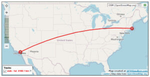 Anyway, here’s my solution (click to zoom): New Bedford, MA (EWB) to Fullerton, CA (FUL), a 2597-mile flight over 17 U.S. states: Massachusetts, Rhode Island, Connecticut, New York, Pennsylvania, Ohio, Indiana, Illinois, Iowa, Missouri, Nebraska, Kansas, Colorado, Utah, Arizona, Nevada, California.
Although the illustration may suggest otherwise, the flight path is “straight” insofar as it represents the shortest distance between the two airports. Several state flyovers are very close calls, and the flight path over Lake Erie comes within yards of the Canadian border. Nonetheless! I challenge like-minded map nerds to come up with an 18-state solution, or a 17-state solution that is strictly overland (excepting rivers).


 May as well fold it over your head and take a nap on the sofa.
")